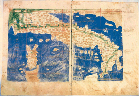
Italy and the Adriatic Sea during the XI century as they are represented in the Code Urbinas Graecus 82 stored in the Vatican Apostolic Archive.
It is the most ancient cartographic code of Ptolemy’s work to have come down to us.
Here, as it is possible to notice even in the following information sheets accompanying the most ancient Ptolemaic documents, the part related to the Eastern side of the Adriatic Sea is almost always badly defined and poorly accompanied by toponymy and iconographic elements in the tabulae SESTAE regarding Italy; these characteristics are almost the same in the Latin codes, even if sometimes there are variations in the illustration and in the content.
The inscription ILLIRIDIS DALMATIE PARS stands out in the map, on the top, right side. It identifies the lands between the oriental side of Adriatic and the Danubian world. Istrian peninsula is illustrated, at the point where two pages of the code meet, like a stocky objects stretching out towards the sea.
Very particular but really implausible is the shape of a triangular gulf given to the upper Adriatic, influenced by the Ptolemaic mistakes.
-
 Language
 Italian

